


Beinisvørð Promontory
Jump to chapter
Published: 02/06/2021
Reading time: 3 minutes
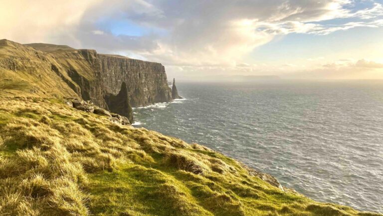
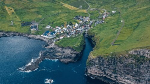
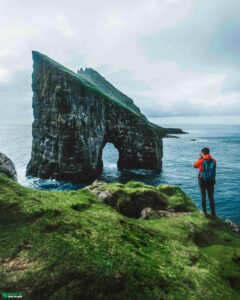
Beinisvørð Promontory is the most famous peak in Suðuroy Island in the untamed Faroe Islands. This cape is located northwest of the village Sumba. Beinisvørð Promontory is a striking 470 m (1542 feet) sea cliff making it the highest cliff on the island.
The impressive cliff towers high above the village Lopra. Here the landscape falls to a sheer drop with the Atlantic Ocean below.
Two Ways to Experience Beinisvørð Promontory

There are basically two ways to experience Beinisvørð Promontory at its best. You can either see the sheer cliff from a distance or go to the top of the cliff itself for jaw-dropping views. Choose between one of the ways to experience the attraction or if you have time for it go for both options.
- From Eggjarnar Vista
- From near the mountain road between Lopra and Sumba
When you take the meandering mountain road Hesturin from the village Lopra to Sumba, you will get on top of Beinisvørð Promontory. At a certain point on the road, you will see a sign pointing to the attraction. Here you can pull off the car and park before walking your way to the edge on top of the mighty cliff.
Just be very careful and keep a safe distance to the very edge. You will get the most awe-inspiring views of the rugged west coast on Suðuroy Island from the top of Beinisvørð Promontory. Be amazed by the height of the place and the skerries, sea-stacks and more!
You will also see the mountain in the distance from Eggjarnar Vista. In order to reach Eggjarnar Vista, you will drive from the village Vágur on an unpaved path for a while.
When to see the Attraction

Beinisvørð Promontory is best experienced from March to November. In depth of winter from December to February might very well see the roads leading to Beinisvørð Promontory covered in snow making it difficult to reach the viewpoints.
Enjoying this cliff is one of the best things to do when you have arrived with the ferry to Suðuroy Island. Always check the weather forecast before setting off. This applies to both ways to experience the attraction as winds can blow stronger than you can even imagine.
One more important thing to take into account is the visibility from the top of Beinisvørð Promontory. Due to its high altitude, the peak itself is often covered in clouds. If unable to see the summit and the cliffs in your first attempt, you might just want to return some hours later. The weather in the Faroe Islands is ever-changeable and the visibility might very well be just perfect when going to this place a second time. Eveven with only hours between visiting, the views you get can be very, very different.
More travel blogs


Popular tours
-
Epic 8 Day Summer Self Drive Tour of Faroe Islands
Tour startsVágar AirportDuration8 days -

3 Day Summer Self-Drive | Sea Cliffs & Uncrowded Villages
Tour startsVágar AirportDuration3 days -

Mykines Shuttle Boat
Tour startsSørvágurDuration4 hours -
From Tórshavn: Kallur Lighthouse on Kalsoy Island
Tour startsTórshavnDuration8 hours -

The 5 Day Photography Tour | Faroe Islands Highlights
Tour startsTórshavnDuration5 days -

Thrilling 4 Hour Ásmundarstakkur & Rituskor Tour
Tour startsHvalbaDuration4 hours -

Spectacular 7 Hour Vágar Island Day Tour
Tour startsTórshavnDuration7 hours -

Stunning Hvannhagi Hike on Suðuroy Island
Tour startsTórshavnDuration12 hours -
Spectacular 12 Hour Suðuroy Island Day Tour
Tour startsTórshavnDuration12 hours -

Amazing 6 Day Self Drive Tour of Faroe Islands
Tour startsVágar AirportDuration6 days -
Best 7 Hour “All You Can See” Tour
Tour startsTórshavnDuration7 hours -

Engaging 2.5 Hour Tórshavn in a Seashell Tour
Tour startsTórshavnDuration2.5 hours -

Spellbinding 5 Day Summer Vacation Package of the Faroe Islands
Tour startsTórshavnDuration5 days -
Private Escorted Tour of main Faroe Islands
Tour startsStreymoy IslandDuration6 hours -
Incredible 3 Day Faroe Islands Highlights Package
Tour startsTórshavnDuration3 days


Frequently asked questions
Where is Beinisvørð located?
Beinisvørð Promontory is located on Suðuroy Island facing the island's rugged west side.
How do I get to Beinisvørð from Tórshavn?
Getting to Beinisvørð Promontory from Tórshavn involves taking a 2 hour ferry and then driving south on Suðuroy Island for 25 minutes.
Can I drive up to the top of Beinisvørð?
Beinisvørð Promontory rises 469 metres (1,539 feet) above the sea, and you can drive most of the way up. Park at around 400 metres (1,312 feet), then walk the final 500 metres (1,640 feet) to the edge of this vast cliff.
How high are the cliffs at Beinisvørð?
Beinisvørð Promontory peaks at 469 metres (1,539 feet) above the ocean.
Is it safe to walk near the edge of Beinisvørð?
Yes, it is safe to stand at Beinisvørð Promontory. As always, be very careful when out in the wild nature in the Faroe Islands. Wind is the single most important thing to watch out for. When the wind gets more than 20 m/s (45 mph), avoid getting close to the cliff.
When is the best time to visit Beinisvørð?
You can visit Beinisvørð Promontory all year round. Just be aware that winter can get very windy some days and that snow might make it difficult to get to the top of the cliff between November through March.
Is there an alternative way to experience Beinisvørð?
Yes, head to Eggjarnar Vista near the village Vágur. From here you will have stunning views of Beinisvørð Promontory and the wild coastline. You can drive all the way to Eggjarnar Vista.
Other interesting Attractions